Cotentin Peninsula
This gristly part of Normandy, located within the department of Manche, is accessible via three ports – St. Malo, Ouistreham and Cherbourg. The latter has a handy summer fast service to and from Portsmouth while for the rest of the year it links with the less handier Poole. Ouistreham features day and overnight services to and from Portsmouth throughout the year. There is a wee bit of confusion as timetables all refer to Caen, rather than Ouistreham, which is a speedy hour’s ride up the canal from the actual port. Approaching from ‘Caen’, there are the D-Day landing beaches of Gold, Sword and Juno, and Bayeaux. The overnight service to St. Malo is more frequent than the return overnight service and so it may be a better starting point than finish. From St. Malo the approach takes in Mont Saint Michel. Cyclists can utilise parts of the Tour de Manche, a cycle route, off and on-road, that runs between Poole and Plymouth, and, Roscoff and Cherbourg. More here: http://www.francevelotourisme.com
http://en.normandie-tourisme.fr/docs/7206-1-cycling-in-normandy-2015.pdf
http://en.tourdemanche.com/itineraires/tour-de-manche-1
Flanked by a marshy apron, the spine of Cotentin is hilly with attractive villages scattered atop the hills and along the valleys. In spite of much of the Tour de Manche being an disused railway, the path has plenty of slow, lengthy climbs to keep the elevation ticking over.
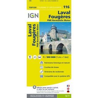
Some mappage. The IGN maps used are 5.99 (May 2016) at Dash4it - See Dash4it code on the left for extra discount.


http://en.normandie-tourisme.fr/docs/7206-1-cycling-in-normandy-2015.pdf
http://en.tourdemanche.com/itineraires/tour-de-manche-1
Flanked by a marshy apron, the spine of Cotentin is hilly with attractive villages scattered atop the hills and along the valleys. In spite of much of the Tour de Manche being an disused railway, the path has plenty of slow, lengthy climbs to keep the elevation ticking over.
Some mappage. The IGN maps used are 5.99 (May 2016) at Dash4it - See Dash4it code on the left for extra discount.


Mont Saint Michel
After a brief shimmy to get out of St. Malo, we cruised down to the coast. The TdM is a perfectly rideable, lightly gravelled path right on the front.
If you haven’t done villages in France much, coffee with pastries is a must. Most bars don’t do both and so, usually, there is a mouth-watering Boulangerie –Patisserie (Baker) very near with very fresh croissants, pain au raisin, pain au chocolate as standard, plus the no-no-oh-all-right-then naughty cakes glistening in a chilled counter. Coffee is served with aplomb –with a cheeky biscuit and, more often than not, milk in a separate jug. All part of the flavour…
 The TdM (not pronounced tedium) continues on, alternating between road and path, until the crossing point on the Couesnon river at Beauvoir from which you head north to the Mont. The signage through the marshes is a little half hearted so beware.

We weren’t planning on visiting the Mont – we just wanted an up-close browse. Even in early May, the tide-free road and pavement were choc-a-block with pilgrims, whose number we joined, heading towards this World Heritage Site, home to forty-four monks and nuns of the Monastic Fraternities of Jerusalem. Any resemblance in name and character to St Michael’s Mount in Cornwall is entirely deliberate as, back in the day, the latter was given to the abbey of Mont St Michel by Edward the Confessor.
 The new road, built in 2014, ensures constant visiting hours with no irksome nature disrupting the flow of cash. It is a site to behold – even from half a mile – the closest we could get on our annoying bikes without digging our pedals into the unsuspecting calf muscles of our fellow pilgrims. Nearby roads were also rammed with queuing traffic, thirsty for a car park.
Heading east, the TdM meanders all over the place and so we took a main road until Bas Courtils where we rejoined the TdM before picking up the traffic free cycle path just after Pontaubault. This last bit is very pleasant as your cross over the La Sélune river.

The path, a disused railway, has a firm but not paved surface with a light coating of aggregate. There are, for the most part, trees or hedges either side but the views are only partially obscured. The gradient can be quite draining as gentle as it is the hill will go on and on but much better than the roads, in any case.
The municipal campsite in Saint Hilaire de Harcouët, Sélune, is small and tidy and cheap (9€50 for two) with great grass, and not too far from a Carrefour supermarket.
61.1 miles 819 ft elevation

Day twoThat old chestnut of packing up a wet tent. If you fold up a dry inner with a wet outer and squeeze them into a tent bag, the inner is likely to get damp. If you have a warm wind first thing, a good quality lightweight tent may dry in an hour. Alternatively, I have front panniers that use for the inner and outer tents, keeping them apart. If I stop for half an hour, I whip them out for a bit of a breeze.
So, with a bit of rain and the usual dew, the tents were wet…We rejoined the TdM for a short ride to Mortain to the north-east. It was here that we encountered the first reference to the Battle of the Cotentin Peninsula, part of the wider Battle of Normandy in WW2. Allied forces, primarily American, landed to north on Utah Beach on D-Day and elsewhere on the peninsula. Meanwhile the Battle of Cherbourg ensued as the Allies secured more of Manche. The eventual success of the Normandy Landings pushed the Germans back until they undertook an ill-fated counter attack on Mortain.

Mortain suffered severe destruction during the war and like many towns in Normandy it was quickly rebuilt after the war. One building, L’ Abbe]aye Blanche, just down the road in Nuefbourg, got away unscathed – which, in some people’s books, was a pity.
Nice boulangerie and café in NeufBourg.
The TdM rises slowly but surely, to almost 1000ft and the long straight inclines, hemmed in by avenues of high trees, the path does have a touch of tedium about it. We were cycling along on a Saturday and the path was deserted – as it would be the following day. A road bike might be a bit vulnerable to being chipped by gravel but any other kind of bike should have been out in abundance.

France: twice the size of the UK physically with about the same population yet the countryside always seems disproportionately deserted.

Minor roads are ideal with little traffic but roll into a large village hungering for a café you might only find a very handy Coiffure if you are in desperate need of a hair-do.

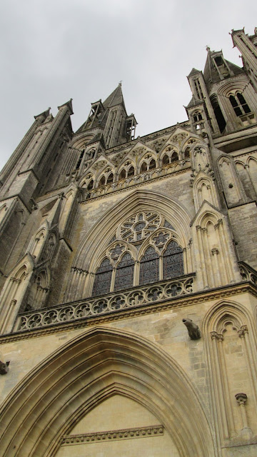
The TdM meanders quietly up through to just west of Vire at which point it veers east and then north towards Carentan. We took to the roads to head north-west to Coutances through Percy and Hambaye.The hillage in this 25-mile stretch was of the steep, rolling type, with one valley after another through lovely, tranquil scenery. There was the occasional mega tractor to contend with on the narrow roads as it went about its agricultural business. We stopped off for pizza beneath a blazing sun at a deserted village restaurant. As the afternoon wore on, clouds assembled behind and in front in preparation for the night’s forthcoming entertainment – heavy rain and lightning etc. We managed to get the tents up in between showers before we walked up to the bustling town centre in the throes of a Jazz festival. The town features an over-sized church that can be seen for miles. Not content with just one pizza, we had another.
The campsite is down a hill to the west of the town centre. It features stand-up crappers, which are always good for a laugh. Urban sites possess the risk of increased barkage – intoxicated shouty people wandering about, over-excitable teenagers out terrorising park benches with their smoking and incessant text-messaging, and groaning traffic. 11€04 for the pitch.


Heading east, the TdM meanders all over the place and so we took a main road until Bas Courtils where we rejoined the TdM before picking up the traffic free cycle path just after Pontaubault. This last bit is very pleasant as your cross over the La Sélune river.


Day two
That old chestnut of packing up a wet tent. If you fold up a dry inner with a wet outer and squeeze them into a tent bag, the inner is likely to get damp. If you have a warm wind first thing, a good quality lightweight tent may dry in an hour. Alternatively, I have front panniers that use for the inner and outer tents, keeping them apart. If I stop for half an hour, I whip them out for a bit of a breeze.
So, with a bit of rain and the usual dew, the tents were wet…
We rejoined the TdM for a short ride to Mortain to the north-east. It was here that we encountered the first reference to the Battle of the Cotentin Peninsula, part of the wider Battle of Normandy in WW2. Allied forces, primarily American, landed to north on Utah Beach on D-Day and elsewhere on the peninsula. Meanwhile the Battle of Cherbourg ensued as the Allies secured more of Manche. The eventual success of the Normandy Landings pushed the Germans back until they undertook an ill-fated counter attack on Mortain.

Mortain suffered severe destruction during the war and like many towns in Normandy it was quickly rebuilt after the war. One building, L’ Abbe]aye Blanche, just down the road in Nuefbourg, got away unscathed – which, in some people’s books, was a pity.
Nice boulangerie and café in NeufBourg.
The TdM rises slowly but surely, to almost 1000ft and the long straight inclines, hemmed in by avenues of high trees, the path does have a touch of tedium about it. We were cycling along on a Saturday and the path was deserted – as it would be the following day. A road bike might be a bit vulnerable to being chipped by gravel but any other kind of bike should have been out in abundance.

France: twice the size of the UK physically with about the same population yet the countryside always seems disproportionately deserted.

Minor roads are ideal with little traffic but roll into a large village hungering for a café you might only find a very handy Coiffure if you are in desperate need of a hair-do.

The TdM meanders quietly up through to just west of Vire at which point it veers east and then north towards Carentan. We took to the roads to head north-west to Coutances through Percy and Hambaye.
The hillage in this 25-mile stretch was of the steep, rolling type, with one valley after another through lovely, tranquil scenery. There was the occasional mega tractor to contend with on the narrow roads as it went about its agricultural business. We stopped off for pizza beneath a blazing sun at a deserted village restaurant. As the afternoon wore on, clouds assembled behind and in front in preparation for the night’s forthcoming entertainment – heavy rain and lightning etc. We managed to get the tents up in between showers before we walked up to the bustling town centre in the throes of a Jazz festival. The town features an over-sized church that can be seen for miles. Not content with just one pizza, we had another.

The campsite is down a hill to the west of the town centre. It features stand-up crappers, which are always good for a laugh. Urban sites possess the risk of increased barkage – intoxicated shouty people wandering about, over-excitable teenagers out terrorising park benches with their smoking and incessant text-messaging, and groaning traffic. 11€04 for the pitch.
67.7 miles 4560ft elevation
Day Three

A maverick green way shared path starts a few miles to the east of Coutances. After about 24 miles of winding north this joins the TdM at La Haye de Puits. This was Sunday and the usual ghost town feel of the villages was added to the towns as well. We left the TdM briefly to enter Saint Sauveur Lendelin. The roads surrounding the eerily silent church were packed with cars and it was as if the entire town has been sucked in through the teak doors. But, to our surprise, we found the butcher, baker and candlestick maker all open for business – well, the baker at least – plus a bar and a shop open all day on Sundays – very unusual.

The path heading west to Carentan is straight and flat and by the time we left it behind to join the D338 just past St Jores the tedium was beginning to set in. Just as with the previous day, there were very few people out enjoying this great resource. Ideal for walking, running, cycling we only saw one group of cyclists and they were from Barnstaple, doggedly following the exact route of the TdM.

We’d shot off north west on the D338 to get to Saint Mère Église –and expected hillage to match Saturday’s but this short ride was easy and pretty, with very little traffic.

Saint Mère Église was an infamous site in the Battle of Normandy. Being the main town and road junction west of the Utah beachhead, it had been targeted by the allies in an airborne attack. Unfortunately as the parachutists descended upon the town they were greeted by spotlights from the town’s buildings and were picked off easily by the Germans. Many never got to the ground and were shot as they hung in trees. The parachute of one paratrooper, John Steele, was caught in the spire of the town’s church. Seeing what had gone on before, Steel pretended to be dead for two hours until the scene below calmed down t which point he was taken prisoner. He escaped and rejoined his division. His story, among others, is depicted in The Longest Day. An action-man style figurine, complete with chute, hangs from the church as a memorial to that day.
On a brighter note, from the D-Day invasion of seventy-six years ago to the Grand Départ of 2016. The TdF is coursing through the Manche in its first three stages and the presentation of the teams will take place in the town square below the church in Saint Mère Église. There is a short ride down to the beach passing through flatlands that were flooded by the Germans as a defence against an invasion. In the end, the flooding, instead, prevented an effective German counter attack. To honour some of the GIs that died in the Utah Beach landings roads have been renamed.
Utah Beach Campsite 14€50 for two. There is very little in the way of café-life at this sombre end of the beach. The campsite’s bar and shop shut at 7.00pm – maybe as we were not in peak season. The shop does have basics and takes a bread order for the morning. Good shower block.


The path heading west to Carentan is straight and flat and by the time we left it behind to join the D338 just past St Jores the tedium was beginning to set in. Just as with the previous day, there were very few people out enjoying this great resource. Ideal for walking, running, cycling we only saw one group of cyclists and they were from Barnstaple, doggedly following the exact route of the TdM.

We’d shot off north west on the D338 to get to Saint Mère Église –and expected hillage to match Saturday’s but this short ride was easy and pretty, with very little traffic.

Saint Mère Église was an infamous site in the Battle of Normandy. Being the main town and road junction west of the Utah beachhead, it had been targeted by the allies in an airborne attack. Unfortunately as the parachutists descended upon the town they were greeted by spotlights from the town’s buildings and were picked off easily by the Germans. Many never got to the ground and were shot as they hung in trees. The parachute of one paratrooper, John Steele, was caught in the spire of the town’s church. Seeing what had gone on before, Steel pretended to be dead for two hours until the scene below calmed down t which point he was taken prisoner. He escaped and rejoined his division. His story, among others, is depicted in The Longest Day. An action-man style figurine, complete with chute, hangs from the church as a memorial to that day.

On a brighter note, from the D-Day invasion of seventy-six years ago to the Grand Départ of 2016. The TdF is coursing through the Manche in its first three stages and the presentation of the teams will take place in the town square below the church in Saint Mère Église.
 There is a short ride down to the beach passing through flatlands that were flooded by the Germans as a defence against an invasion. In the end, the flooding, instead, prevented an effective German counter attack. To honour some of the GIs that died in the Utah Beach landings roads have been renamed.
Utah Beach Campsite 14€50 for two. There is very little in the way of café-life at this sombre end of the beach. The campsite’s bar and shop shut at 7.00pm – maybe as we were not in peak season. The shop does have basics and takes a bread order for the morning. Good shower block.
49.2 miles 1299ft elevation
Day Four


The weather finally headed us off at the pass despite managing to get a dew free night. The beaches looked unappealing with grey choppy water frothing away over the mussel beds that spread along just below the low tide mark. From a distance they could have been people paddling, or, having a tendency to be melodramatic, soldiers wading ashore.

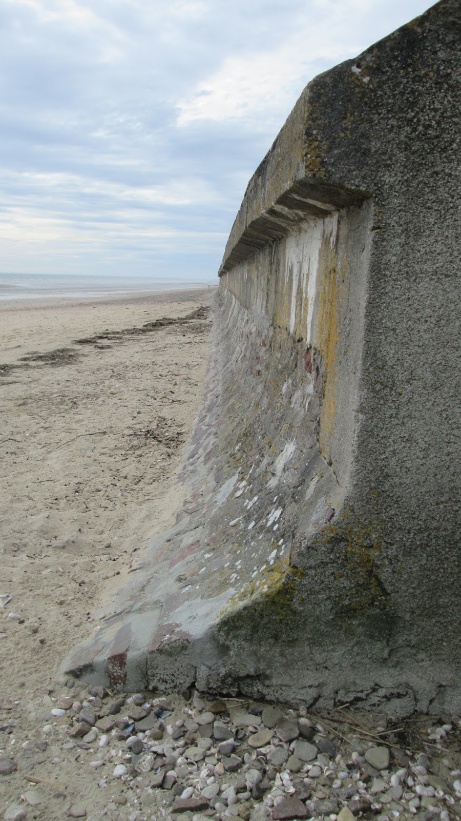
The German defences have been left as they were in June 1944. If you felt inclined you could fall down the hole that housed the gun turret on the reinforced concrete emplacements.

A derelict sea wall remains exposed just above the high tide mark. Should these relics have been removed?

The defences go on right up the bay; cast your eye along the dirty waters. The horrors of that day are rendered in Saving Private Ryan, the first thirty minutes being one of the most shocking in movie history.

There are a handful of campsites on the bay but very little else. It is not a tourist destination other than for the Utah Beach museums at either end of the bay. We flock to the south coast but why would the French come here when they have the west coast and the Riviera? The flatlands here and the dull beach do not offer much and the lack of amenities reflect that – nearly eight miles before we found bar – and it neighbouring boulangerie – in Quinéville. The Tdf is going right past the front door of the cafe...
 We continued slightly inland on the D14 to the pleasant Saint Vasst la Hougue before stopping at the tiny port of Barfluer for a seafood salad. The coast here is reminiscent of Scotland’s west with dashes of bright yellow gorse in amongst the dull, weatherproof houses. The last few miles to Cherbourg were knocked without much fuss.From Saint Vaast the going was pretty easy but for one shocker of a 10%.


The weather finally headed us off at the pass despite managing to get a dew free night. The beaches looked unappealing with grey choppy water frothing away over the mussel beds that spread along just below the low tide mark. From a distance they could have been people paddling, or, having a tendency to be melodramatic, soldiers wading ashore.

The German defences have been left as they were in June 1944. If you felt inclined you could fall down the hole that housed the gun turret on the reinforced concrete emplacements.

A derelict sea wall remains exposed just above the high tide mark. Should these relics have been removed?
The defences go on right up the bay; cast your eye along the dirty waters. The horrors of that day are rendered in Saving Private Ryan, the first thirty minutes being one of the most shocking in movie history.

There are a handful of campsites on the bay but very little else. It is not a tourist destination other than for the Utah Beach museums at either end of the bay. We flock to the south coast but why would the French come here when they have the west coast and the Riviera? The flatlands here and the dull beach do not offer much and the lack of amenities reflect that – nearly eight miles before we found bar – and it neighbouring boulangerie – in Quinéville. The Tdf is going right past the front door of the cafe...
 We continued slightly inland on the D14 to the pleasant Saint Vasst la Hougue before stopping at the tiny port of Barfluer for a seafood salad. The coast here is reminiscent of Scotland’s west with dashes of bright yellow gorse in amongst the dull, weatherproof houses. The last few miles to Cherbourg were knocked without much fuss.From Saint Vaast the going was pretty easy but for one shocker of a 10%.
47.3 miles 1211ft elevation
